Seattle Sea-Tac Airport (SEA)
Driving Directions / Travel by Car
(Seattle, Washington - WA, USA)
Well connected to the Washington network of highways, Seattle Tacoma International Airport (SEA) is situated close to the I-5 interstate, which runs in a north-south direction and links many cities along the way. Seattle Airport is especially close to Burien and Normandy Park, both of which lie to the west, while Tukwila and Renton can be found to the east.
Also nearby Sea-Tac Airport, the Renton Municipal Airport is sited to the northeast, with Des Moines to the south, and the Rainier Country Club, North Seatac Park and the Sunset Playfields all being located to the north.
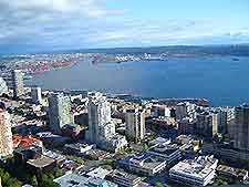
Prominent landmarks close to Seattle Airport include Lake Washington to the northeast, a vast expanse of water which dominates the area and is surrounded by a variety of waterfront attractions. Mercer Island is situated in the center of Lake Washington.
Directions to Seattle Tacoma International Airport (SEA) from the north:
- Take the main Interstate I-5 road and exit at 154B
- Continue in a westerly direction on the State Route 518. The route is clearly signposted from this point
Directions to Seattle Tacoma International Airport (SEA) from the south:
- Take the main Interstate I-5 road and leave at exit at 154
- Continue in a westerly direction on the State Route 518, following the signposts
Directions to Seattle Tacoma International Airport (SEA) from the east:
- Take the main Interstate I- 405 road
- Continue along the State Route 518 and follow the signposts
Seattle Sea-Tac Airport (SEA): Virtual Google Maps
